Navigational maps are very important tools for surveying the land. The objective of this lab was to create two separate maps of the Eau Claire Priory that will be used in a future lab. When mapping real world landscapes, it is important to use the correct coordinate system and map projection. A geographic coordinate system defines locations on the earth by using a three-dimensional spherical surface. Latitude and longitude values give a specific position to data points referenced on a map. A map projection is taking a three-dimensional spherical surface, like earth, and displaying it on a flat surface. There are many different types of coordinate systems and map projections, but certain types fit better with the specific data being used. For this lab, the WGS_1984_UTM_Zone_15N coordinate system and the Transverse Mercator projection were used.
Methods:
To start, the WGS_1984_UTM_Zone_15N coordinate system needed to be projected onto the map. The Universal Transverse Mercator (UTM) coordinate system divides the world into 60 north and south zones that are 6 degrees longitude sections wide and are defined in meters. The Eau Claire Priory is located within the UTM zone 15 which is why this coordinate system was used (Figure 1). The study area that fits best within a certain UTM zone should be the one that is used to maximize the best results and avoid distortion.
 |
| Figure 1: United States UTM Zones |
After the designated coordinate system was applied, the map could be created. A priory geodatabase was provided for the assignment that included all of the necessary information needed for this lab including lidar data, an Eau Claire basemap, elevation contour lines, and a navigational boundary of the Priory. First. the piorylidar raster and the priory_5ft line feature class were added into ArcMap to gain an idea of the terrain of the Priory (Figure 2). There was actually three different rasters of the lidar that was mosaicked into one for better imagery.
 |
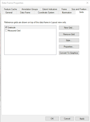
| Figure 3: Grid Properties in Data Frame Properties |
Lastly, the maps were resized to 11x17 in the landscape format in print and page properties. Then, the final map elements were added: title, north arrow, scale, representative fraction bar, data sources, contour, description of coordinate system and projection, and water mark. The maps were then exported as PDF files.
Results/Discussion:
Two separate navigational maps of the Eau Claire Priory with different grid systems were created during this lab. One map shows the Measured Grid that contains a UTM grid at 50 meters spacing (Figure 4) and the other shows a Graticule that provides geographical coordinates in decimal degrees (Figure 5).
 |
| Figure 4: Measured UTM Grid of the Eau Claire Priory |
 |
| Figure 5: Geographical Coordinates in Decimal Degrees of the Eau Claire Priory |
The maps created in this lab will very helpful when analyzing the Priory in a future lab. The importance of geographic coordinate systems and projections are showcased in this lab as well. Evaluating physical maps can be important for looking at spatial locations as well as digital maps.
Sources:
https://support.esri.com
http://www.xmswiki.com/wiki/UTM_Coordinate_System

No comments:
Post a Comment